O Programa de Monitoramento BiomasBR atualizou, em 3 de março de 2026, os dados do monitoramento anual da supressão de vegetação nativa no Brasil.
Essas atualizações impactam todos os arquivos relacionados à supressão de vegetação nativa. Recomenda-se, portanto, que os usuários atualizem suas bases de dados.
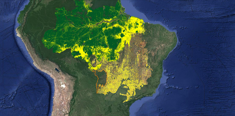
A ampliação do sistema de detecção do desmatamento em tempo real - DETER, passa a disponibilizar alertas de alterações na cobertura vegetal no bioma Pantanal e em área de fitofisionomias Não Florestais na Amazônia à partir de 2023.
Acesse os relatórios online com o resumo dos dados:
Neste caso, é necessário realizar um procedimento de paginação que nos possibilitará obter todos os dados disponíveis na camada.
Neste exemplo, usamos o valor de 100 registros para ilustrar o processo, mas este valor pode ser ajustado até o valor máximo permitido pelo servidor, informação que também está descrita no artigo supracitado.
Os atributos de controle relevantes são:
count (define a quantidade de registros por página de resultado)
startIndex (define o número do próximo registro incluído no resultado)
sortBy (usado para ordenação dos dados, permitindo o funcionamento correto da paginação)
Requisição para os primeiros 100 registros, de 0 até 100.
https://terrabrasilis.dpi.inpe.br/geoserver/deter-amz/wfs?service=WFS&version=2.0.0&srsName=EPSG:4674&request=GetFeature&typeName=deter_public&CQL_FILTER=date BETWEEN '2019-01-01' AND '2019-02-01'&outputFormat=SHAPE-ZIP&count=100&sortBy=gid&startIndex=0
Requisição para os próximos 100 registros, de 101 até 200.
https://terrabrasilis.dpi.inpe.br/geoserver/deter-amz/wfs?service=WFS&version=2.0.0&srsName=EPSG:4674&request=GetFeature&typeName=deter_public&CQL_FILTER=date BETWEEN '2019-01-01' AND '2019-02-01'&outputFormat=SHAPE-ZIP&count=100&sortBy=gid&startIndex=100
Note que a ordenação é muito importante e o ideal é que seja utilizado um atributo do dado que seja único, como no exemplo, usamos o identificador gid para ordenação. Para descobrir quais atributos existem em uma camada, veja a sessão “Pesquisando os atributos de uma camada via “DescribeFeatureType” do artigo “Download de dados“
Ao publicar grandes volumes de dados via GeoServiços algumas restrições devem ser consideradas principalmente quando os recursos computacionais são escassos.
Neste sentido, existem algumas opções que nos permitem aplicar estas restrições e uma delas diz respeito ao número máximo de Features, ou de maneira mais simples, linhas na tabela entregue como resultado para cada consulta GetFeature ao serviço WFS (versão 2.0.0).
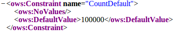
Na plataforma TerraBrasilis o número máximo de registros entregues em cada requisição está restrita a 100.000 linhas. Note que este número pode mudar e portanto você deve esperar que ele mude em algum momento no futuro. Assim sendo, a primeira dica é, consulte o valor real no documento de capacidades do serviço, fazendo a requisição GetCapabilities e procurando pelo parâmetro “CountDefault” no resultado, como se vê na figura 1.
Outro número importante é a quantidade real de registros existentes na camada. Note que este número é diferente da restrição mencionada acima, podendo ser inferior ou superior. Em um paralelo com bancos de dados, o resultado que estamos procurando é a resposta para a seguinte query: “SELECT COUNT(*) FROM tabela”.
Para obter este valor usando uma consulta WFS, usamos o parâmetro opcional “resultType” em uma requisição GetFeature.
INPE participará da feira MundoGeo Connect 2019, em São Paulo, onde serão apresentados os projetos de monitoramento ambiental dos biomas brasileiros que estão sendo executados com apoio financeiro do Ministério da Ciência, Tecnologia, Inovações e Comunicações (MCTIC), Fundo de Investimento Florestal (Banco Mundial) e Fundo Amazônia (BNDES).
No dia 26 de junho, informações e resultados dos projetos serão apresentados em uma sessão de palestras, assim como será realizada uma demonstração do portal de divulgação de dados geográficos TerraBrasilis desenvolvido pelo INPE.
Atualmente os dados dos programas PRODES e DETER, disponíveis no portal TerraBrasilis, podem ser obtidos de duas formas:
Via download direto de arquivos, acessando a página de download;
Baixando dados via serviço WFS;
Até a presente data, 02 de maio de 2019, a ferramenta visual para download seletivo de dados usando filtros ainda não foi disponibilizada. Esta funcionalidade está em nossa lista de requisitos e será disponibilizada assim que possível.
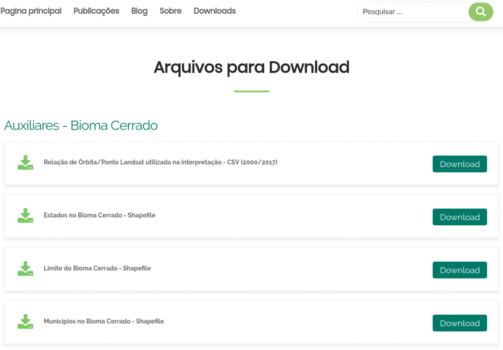
Página de download de arquivos
A opção básica oferece arquivos por categoria de dado e bioma. São arquivos completos e compactados para quem quer todo o dado disponível.
https://terrabrasilis.dpi.inpe.br/downloads/
Baixando dados via serviço WFS
Serviços padronizados nos ajudam a flexibilizar o acesso pois permitem a utilização de ferramentas existentes no mercado que entendam estes padrões mas também permitem a construção de nossas próprias ferramentas. O serviço WFS (Web Feature Service) possui um amplo vocabulário e não pretendemos explorá-lo por completo. Iremos demonstrar apenas uma forma de obtenção de dados tomando como exemplo a camada de Alertas do projeto DETER para a Amazônia Legal.
Usando o software QGIS
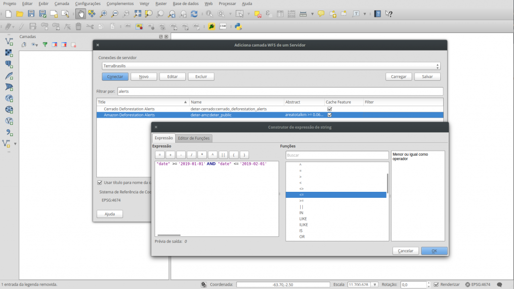
Uma opção para explorar os dados usando uma interface gráfica é o software QGIS. A ferramenta padrão de adição de camada WFS permite visualizar e baixar os dados disponíveis. Os passos necessários são:
Inserir a URL (https://terrabrasilis.dpi.inpe.br/geoserver/ows) como fonte de dados;
Filtrar uma camada na lista;
Selecionar uma camada;
Criar um filtro por atributo;
Adicionar a camada ao mapa;
E por fim, salvar a camada para um arquivo.
Adição de camada WFS com filtro por atributo
Para um passo a passo, recomendo a documentação oficial do QGIS. Existe uma série de posts sobre o assunto na internet e não pretendemos escrever mais um.
Pesquisando as camadas na interface do GeoServer
O acesso à lista de camadas do GeoServer está disponível para consultas na página do TerraBrasilis. Pesquise por “Lista de todas as camadas configuradas no GeoServer“, cujo resultado irá lhe apontar para a lista conforme a seguinte figura. Os itens da lista representam as camadas e deverão apontar para seus respectivos metadados. Estando na página de metadados você pode ler as anotações sobre o dado e as formas de acesso disponibilizadas.
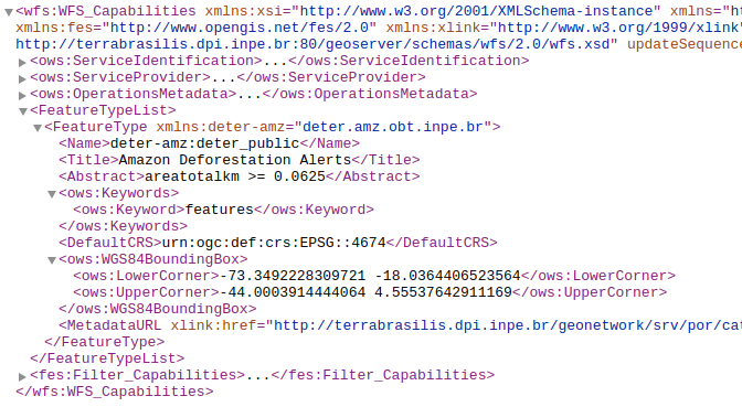
Pesquisando as camadas via GetCapabilities
Exemplo de solicitação dos nomes das camadas disponíveis sob o workspace deter-amz. Para esta tarefa devemos utilizar uma requisição GetCapabilities que nos retornará um XML com todas as camadas deste workspace além das demais operações que podemos aplicar ao solicitar dados via serviço.
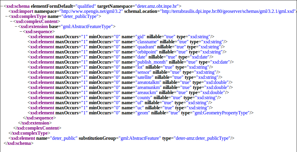
Pesquisando os atributos de uma camada via DescribeFeatureType
Exemplo de solicitação dos nomes dos atributos disponíveis para a camada de dados de interesse. A operação DescribeFeatureType é usada para solicitar estas informações e o retorno pode ser visto a seguir.
E por fim, o exemplo de solicitação dos dados para um intervalo de tempo, usando o atributo “date”. O filtro usa CQL e é formado pelo nome do atributo de interesse e o valor ou o intervalo de valor, como neste exemplo usado para baixar os dados com data entre 01 de janeiro de 2019 a 01 de fevereiro de 2019.
CQL_FILTER=date BETWEEN ‘2019-01-01’ AND ‘2019-02-01’
https://terrabrasilis.dpi.inpe.br/geoserver/deter-amz/wfs?service=WFS&version=2.0.0&srsName=EPSG:4674&request=GetFeature&typeName=deter_public&CQL_FILTER=date BETWEEN '2019-01-01' AND '2019-02-01'&outputFormat=SHAPE-ZIP
É importante salientar que as diferenças de implementação das versões do serviço WFS 1.0.0, 1.1.0 e 2.0.0 pode causar confusão quanto à orientação dos eixos X e Y sendo necessário informar o srsName nas versões 1.1.0 e 2.0.0. veja mais detalhes na documentação do GeoServer que trata deste assunto.
Excelência dos dados do PRODES é destaque no XIX SBSR. Com mais de mil citações registradas na página do PRODES, a qualidade dos dados e resultados recentes comprovam a importância do projeto como insumo para trabalhos científicos de impacto em diferentes áreas do conhecimento. INPE anuncia o lançamento da nova versão do portal de disseminação de dados geográficos TerraBrasilis.
Figura 1 – Coordenadores e Equipe Técnica do TerraBrasilis
Com o intuito de ampliar o alcance dos programas de desmatamento (PRODES) e de detecção de alertas (DETER), o INPE vem desenvolvendo uma infraestrutura de dados espaciais denominada TerraBrasilis para facilitar a visualização e o acesso desses dados assim como as estatísticas relacionadas a eles. Por meio de sistemas de informação geográfica na Web e padrões de interoperabilidade, oferece funcionalidades de sistemas de apoio à decisão.
Ele também disponibiliza APIs para facilitar a análise desses dados espaciais em ambientes analíticos como os da linguagem R. A versão beta da plataforma foi divulgada no 19º Simpósio Brasileiro de Sensoriamento Remoto (Figura 1).
Para mais informações técnicas, acessem o nosso artigo científico publicado e disponível no seguinte link: https://bit.ly/2IyPVJ2.